![]()
|
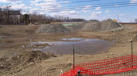
April 13, 2002 |
|
This picture was taken from Route 7 looking north in Corinna. This is the former location of Main Street, the old river channel and much of the mill. Some of the mill foundation can still be seen behind the piles of crushed rock. This gaping hole was created when the contaminated soil was excavated from the river bed and surrounding areas. At the height of the excavation last summer the hole was 39 feet deep. Soon the extension of Route 43 will be built across the area connecting to Route 7. |
![]()
Next | Previous | Homepage | Archive
![]()