![]()
|
Lately, in Corinna... December 2, 2000
|
|
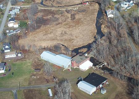
This aerial was taken on November 4, 2000. It shows the lower mill, the brick building near the center, down at the end of Mill Street. The wooded area to the right was the site of the Moosehead Woolen Mill. It was destroyed by fire in 1950. At that time, it was the second largest woolen mill in Maine. The Lower Dam is just to the right of the building, mostly hidden in the photo. The open area above the dam used to be the Lower Mill Pond. The structure crossing the river below the mill is the old bridge. It is blocked and no longer maintained. At the top of the photo you can see the gravel road built out into what use to be the pond. The red machinery is a drilling rig, part of the EPA testing program. |