![]()
|
Lately, in Corinna... June 28, 2000 |
|
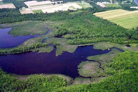
Looking roughly east, this is the northern end of the river as it widens out just below Corinna. The fields of Thunder Road Farm along the Newport Road show at the top. The red spot in yesterday's picture would be off to the left along the point of land that runs out of the picture. From the largest section of open water, in the middle, there is a channel that runs up in an "s" curve and off to the right into some trees. It is marked with a blue spot. That is the main channel of the East Branch of the Sebasticook River coming down from Main Street. The yellow spot on the right marks the channel of the Alder Stream entering the area. Notice that while the water has a brown color, it is clear enough to see the bottom in some areas. |
![]()
Next | Previous | Homepage | Archive
![]()