OCTOBER 1999
![]()
|
Lately, in
Corinna...
|
![]()
![]()
|
Lately, in
Corinna...
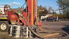
Question: If you are drilling a well where the soil, bed rock and ground water are contaminated with chlorobenzene, what should you do with the it? Answer: Store it in barrels. At least some of the wells have produced a number of steel drums filled with the gray stuff. I'm sure it will be decontaminated with the other 30,000 cubic yards of soil to be treated after the mill is demolished. |
![]()
![]()
|
Lately, in
Corinna...
This is a photograph of the approved plan. It moves Route 7 to the south of the present Main Street passing south of the existing Odd Fellows Hall. The river is moved west so that it will run through what is now Henderson's Store. The orange blocks represent potential buildings in the future. I added the green text identifying some streets. |
![]()
![]()
|
Lately, in
Corinna...
Looking at this photo, I wonder how this strange ninety-degree turn came to be. MORE |
![]()
![]()
|
Lately, in
Corinna...
|
![]()
![]()
|
Lately, in
Corinna...
It's larger than most people realize and an important habitat for water fowl and other wild life. It is "hidden' because there are very few locations from which this entire lake is visible. |
![]()
![]()
|
Lately, in
Corinna...
Click on this picture for a larger view. |
![]()
![]()
|
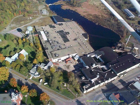
Lately, in
Corinna...
The building will be occupied by the United States Environmental Protection Agency, The U S Army Corps of Engineers and Harding Lawson Associates. (I wonder if anyone else will move in upstairs.) No sign of demolition, yet. |
![]()
![]()
Next | Previous | Homepage | Archive
 As
part of the Remedial Investigation Harding Lawson Associates is drilling
monitoring wells behind the stores on Main Street, along both sides of
the river, in the river bed itself and in other locations. Data gathered
from the wells will help determine the extent of contamination and how
it may still be spreading. This rig is across the street
from Lister Petroleum, near where Ken's Dairy Creme sat many years ago.
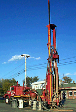
As
part of the Remedial Investigation Harding Lawson Associates is drilling
monitoring wells behind the stores on Main Street, along both sides of
the river, in the river bed itself and in other locations. Data gathered
from the wells will help determine the extent of contamination and how
it may still be spreading. This rig is across the street
from Lister Petroleum, near where Ken's Dairy Creme sat many years ago.
 You've
seen the gray stuff that ends up all over the ground when someone drills
a well.
You've
seen the gray stuff that ends up all over the ground when someone drills
a well.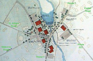 Last
night the selectmen of Corinna accepted the recommendation of the
Downtown Revitalization Committee and approved a plan for the redesign
of the Corinna village and Route 7.
Last
night the selectmen of Corinna accepted the recommendation of the
Downtown Revitalization Committee and approved a plan for the redesign
of the Corinna village and Route 7.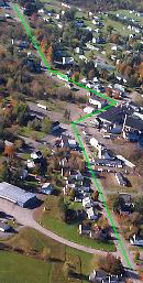 Ever
since I can remember, in fact, ever since my father can remember, there
has been talk about straightening out Route 7 through Corinna. In this
photograph, taken this week from the air over Corinna looking southwest,
you can see Route 7 running from the upper left to the lower right. The
Newport Road comes in from the top. The Dexter Road exits at the bottom
of the photo. I added the green line running along the path of the road.
Ever
since I can remember, in fact, ever since my father can remember, there
has been talk about straightening out Route 7 through Corinna. In this
photograph, taken this week from the air over Corinna looking southwest,
you can see Route 7 running from the upper left to the lower right. The
Newport Road comes in from the top. The Dexter Road exits at the bottom
of the photo. I added the green line running along the path of the road.
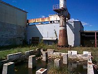 I
heard yesterday that the demolition of the mill will begin during the
last week of October. It can't start soon enough for most of us.
I
heard yesterday that the demolition of the mill will begin during the
last week of October. It can't start soon enough for most of us.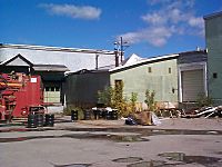 These pictures were taken within 100 yards of Main Street. It will be
nice to have scenes like this disappear. I know that downtown will never
be the same. Certainly it will be better than it is now.
These pictures were taken within 100 yards of Main Street. It will be
nice to have scenes like this disappear. I know that downtown will never
be the same. Certainly it will be better than it is now.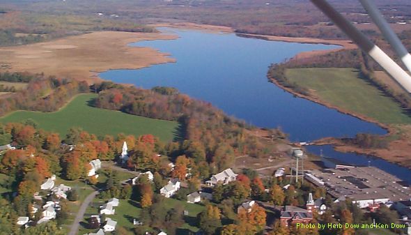
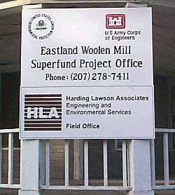 Well,
this must make it official. This sign showed up on the Thurston House
today.
Well,
this must make it official. This sign showed up on the Thurston House
today.